The Santa Paula Trifecta

Out Here on the Perimeter …

It was an unseasonably warm MLK Weekend that ZK and I grabbed two of the pack and headed up Santa Paula Canyon. We had three primary goals:

  1. Reconnoiter the damage done in the East Fork by the 2005 floods (the same ones that brought the hillside crashing down on La Conchita), and see what parts of the route had been lost (and which remained) from Big Cone to Cienega.
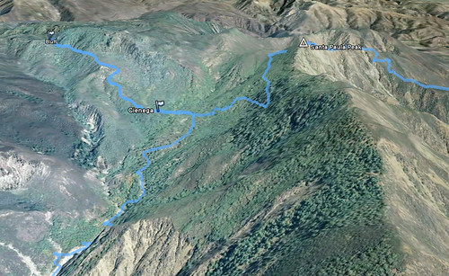
  2. Recon the route from Cienega to Bluff and the formations beyond, which has over the years become something of a “holy grail” site for our crew.
  3. Hit Santa Paula Peak on our way out of Santa Paula Canyon en route to Timber Canyon (this was the simplest of the goals).

Done, done, and done!

Day the First

After a brief skirmish between our pack and a few of the Recuerdo pack (no hard feelings, R pack, we know you were just protecting your turf … all thanks to the private landowners who let folks access this area), we headed past the last two Ferndale pumps and into the canyon. We saw two couples hiking during this early stretch. That was to be our last human contact for 51 hours.

The route up the main fork of Santa Paula Canyon sustained its own damage in 2005, and much of the stretch between the Echo Canyon confluence and where the old road bed heads onto the southern banks has been reduced to a wide, cobble-strewn flood plain. After crossing over to the service road and ascending that portion (all in very good shape, with the exception of the washout that’s rent a massive gouge in the route about half-way along the high portion of the road), we had a brief break at Big Cone and picked around the northern flanks of Hill 1989.

The Crux

We dropped into the East Fork from Big Cone and almost immediately the trail fell off the edge of the canyon into the streambed. We followed some very deftly-placed blue flagging for a while, rock-hopping through alder-choked ravine and witnessing some slots where the debris flow that scoured those side channels must have been epic – canyon after canyon just obliterated by UPS truck-sized boulders on both sides. It was rather humbling.

Soon enough we came to a small guerrilla camp where somebody had built a good kitchen and left a very nice supply of fuel wood. There was a piece of the blue flagging we’d been following skewered into the center of the fire pit, and we therefore suspected this had been the turn-around point for the skilled trailblazer in whose wake we were traveling. (We subsequently christened this site “Blue Flag Camp”.)

More?

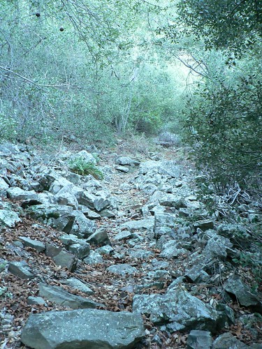
Alas, this indeed proved to be the case. As helpful as the flagging had been, however, its loss didn’t deter our progress overly, as the going was slow – flagging or not. Every time we located a piece of the old route and followed it for a hundred yards or so, it would abruptly come to a sheer drop-off where the raging torrent that was the 2005 East Fork in storm had carved a new angle into the canyon. Back down we’d go, and again into the creekbed. I imagine we missed a few decent bits of trail once we decided to simply keep to the drainage, but I further imagine they’d have just led us to further hikers’ heartbreak anyhow, and so we continued our march/hop/slog eastward. (As an idle point of trivia, in the north- and east-ward arc we made, we saw only 11 minutes of sunlight the entire day, so well-shaded and so deep in the canyon were we.)

As we were reaching what the 1995 7.5’ quad indicated would be the narrowest portion of the canyon, we were forced to recalibrate our definition of the “hard” part. We were suddenly beset on all sides by imposing white-and purple-striped siltstone ravines, which — in ZK’s inimitable vernacular — were like “hiking through Plaster of Paris.” This from a man not given to hyperbole. In light of the recent rains, everything was very loose, very messy, and the dogs were up to their bellies in this ooze. And the ravine was steep. Our already-slow progress slowed further, so much that it didn’t feel like we were making any progress at all. The daylight was burning and we seemed to be barely moving.

We knew there was supposed to be a fairly level track somewhere to our left (north), but couldn’t find a sensible route up to it, and so just slogged on. Can muck be Class 3? This was.

Finally we scrambled over (or in my case, fell through and wriggled out of and over) a few debris jams near the top of this steep and time-sucking ravine, to emerge into a nice meadow hemmed in by big cone Douglas-fir. Another guerrilla camp stood sentinel here, and this one in turn we christened Camp Solitude.

With our remaining light waning, we knew we were close to where on the Santa Paula Peak quad the trail began its switchbacking climb up one of the southern drainages toward Cienega. We found a short piece of track along the river (had we backtracked, I suspect we may have found a piece of that elusive route that could have kept us out of the Grand Plaster of Paris Canyon). As had been the case with other pieces of trail, it petered out within a few hundred feet, so we opted for some dead reckoning. We agreed that if we didn’t find our way before we were critically low on light, we’d bivouac where we could and continue at first light the next morning.

We shot straight up the slope, tramping through duff 18 inches thick, eventually finding a game trail and following it on an easier grade. This game trail soon showed signs of a trail bed. Then I spotted evidence of decades-old trail maintenance just as ZK found some old fence posts buried in the hip of a huge, gnarled live oak. There was hope!

We continued along this old route for another mile, all the while closing in on where we were fairly certain the East Fork and Peak trails would converge. Quite some time after the sun dropped behind Santa Paula Ridge, we spotted an old 4×4 post with a metal USFS badge, and soon thereafter, came to a well-defined trail junction amidst heavy fern, conifer, maple, and oak cover. This stretch of the southern Los Padres has been spared the ravages of fire for most of the last century (I suspect the last fire here was the 1932 Matilija Fire) and easily competes with spots such as Santa Barbara’s Cold Spring Canyon for sheer lushness. It was akin to tramping in the Cascades or British Columbia.

We continued north, and just as my Garmin toggled over from day backlight to night backlight (indicating civil twilight), we walked into the glory that is Cienega.

North Flank, Santa Paula Peak

ZK collected wood and got the fire going, I collected bottles and filtered water, and Lilly and Masha took a well-earned respite from point and perimeter duty, respectively. Fifteen minutes later the dogs were gnawing their ration and we were grilling lamb chops on the fire. A slow day, but a fine one.

We laid our bags out beside the fire and in the small window of sky afforded us by the trees forming the camp’s perimeter, we watched the nearly-full moon come into view. It wasn’t until later we actually zipped up the bags, so warm was the evening. Contrails from overhead jets sat static in the moonlight, so still was the air.

Day the Second

The next morning, we were in no hurry to do much of anything, and so scouted around the site, raking the area around the fire pit, clipping some wayward yerba santa and oak branches along the approach trail, and generally enjoying the environs of this very well-shaded site. In the late morning we packed our day bags, and headed out in search of Bluff camp.

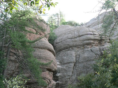
The ascent to Bluff is steep, there’s no reason to pretend otherwise. Given how little traffic it seems to receive, however, the trail was in remarkably good shape, and nowhere near as overgrown as we were expecting. I attribute some of this to the fact the route climbs through primarily “hard” chaparral (manzanita, chamise, mountain mahogany, etc.), which grows far slower than some of the other species. (The route was mercifully free of any thorned varieties of ceanothus.) The red sandstone formations that mark the southwest boundary of the Sespe Condor Sanctuary slowly drew closer, and in time we again found ourselves beneath magnificent groves of big cone Douglas-fir and sugar pine, specimens the would elsewhere find themselves amongst the Ents.

Bluffs No. 1

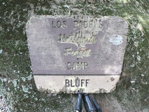
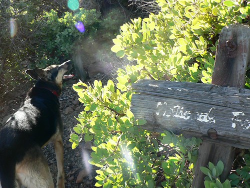
Sitting rather unassuming in all these towering conifers and massive sandstone monoliths and crevices, we found the skeletal remnants of a New Deal-era ice can stove and — half-buried beneath organic detritus — an old wooden sign proclaiming a small flat beside a spring-fed creek to be the vaunted Bluff camp. Were it not for two short logs ostensibly used as benches, I likely wouldn’t have made out the kitchen, to be honest … it had clearly been some time since anybody had used the camp. (ZK, as he is always wont to do, immediately endeavored to rebuild the fire ring, and it is now a very nice spot to cook indeed.)

Once and Future Signage

We headed further up the thinning trail, investigating various crevices and dripping slots along the lower formations. Large flocks of ring-necked doves alighted from their roosts every time we rounded another corner. But for them and a few scrub jays, we saw little else. It was an eerily still spot.

We took our lunch in the old camp, and returned to Cienega for dinner.

Refreshed Redux

Day the Third

The next morning, we didn’t loiter as we had the previous day, but neither did we rush our departure. We headed out toward the Peak/East Fork junction after breakfast, and climbed the long and lovely (and well-shaded) switchbacks toward the gap where the junction with the old route for San Cayetano Peak cuts east. Views were fantastic; we could see the snow-capped San Gabriels, the skyscrapers of downtown Los Angeles, seven of the eight Channel Islands, Lake Casitas, the peaks beyond the Matilija Wilderness, and the Topatopa Mountains. And this only from the saddle!

Andiamo!

We watered the dogs and then continued to the junction with the Santa Paula Peak spur trail, dropping our packs and reaching the site of the old lookout just before noon. Cermak and Blakley both recount how the lookout was spared from the Matilija Fire by an ambitious backfire, only days after the Reyes Peak lookout was consumed. Only the footings and some odd cable and some brackets now remain; add another “to-do” to the list.

Here on Santa Paula Peak, obviously, the view was even better. In addition to those points we could spy from the saddle, now also in view was the tower upon which the Topatopa Peak lookout stood until consumed by the 2006 Day Fire.

From Santa Paula Peak, it was a steep, hot, rocky, tick-infested descent into Timber Canyon. I would certainly recommend against climbing it in such weather with dogs — as we saw a couple attempting to do just before we reached the ranch road — unless you’re carrying ample water for your quadruped companion(s).

After Santa Paula Peak, the rest of our journey did admittedly feel a bit anti-climactic. But knowing (to paraphrase Frost [twice]) exactly how lovely, dark and deep those woods beyond to be — and having learnt some of the East Fork’s secrets — we’re certain to again opt for the path less traveled next time ’round.

Comments

19 responses to “The Santa Paula Trifecta”

  1. Cool trip! How interesting to see that Bluff sign now compared to Bobby Emm’s picture of it years ago. It seems like time is moving more slowly up there. Did the trail beyond Bluff go very far? Was there any snow left? When you say you saw a 4×4 with USFS badge, do you mean there’s an abandon truck up there? That seems…odd. Awesome report.

    Take care,

  2. Ah, good point, EP. I meant a 4″ x 4″ signpost. Touche. 😉

    The trail beyond Bluff went further than we expected … much of it’s grown over, but still fairly easy to follow. No snow.

    thx

  3. I am not engaging in overstatement at all when I describe this entry as a Los Padres adventure opus wrapped in a narrative worthy of, say, Hemingway. Everyone should be enjoying this as much as I am. Such literature on-line makes the Internet worthwhile.

  4. This brought back some funny memories of a time I did Cienega and Bluff. I think it was sometime around 2001. Anyway, four friends and I were attempting SP Cyn up to Cienega and back in a weekend. We started late after dark on a Friday evening. As we made it past the college, past the oil wells and into the cyn we started to hear odd, ritualistic sounds. The further we got into the canyon, the louder the noise. It sounded like singing and drumming, and sounded like there were a lot of people. Now knowing what we knew about that canyon and who visits it, we were a bit apprehensive to go further – afraid we might get jumped or walk into some sort of gang initiation. Long story short, my dog ran ahead into what turned out to be a drum circle of Thomas Aquinas College students and, wait, a full keg surrounded by college girls! Not kidding. I think they were actually more excited than we were because they actually brought us cups of beer and invited us to stay for a while. I don’t think the TA guys were too happy about that. We hung out for a couple hours, sang and drummed with them, chatted, and finished their keg. Beer gone, packs back on, stumbled into Big Cone at some late hour wondering if that had really happened or not. Heading into each backpacking trip since then I hope and pray for a repeat performance, but as of yet – no love. But the search goes on.

    The rest of the trip was much as you describe above. Trail, no trail, trail, no trail – then a perfect Cienega Camp and Bluff. Amazing nook of the forest.

    Great writing Craig – is there a way we can subscribe to these posts so that they come to us?

    1. @Bryan, I think that’s something to which we could all aspire at any point of any trip! And to think I used to find joy in finding a dented can of baked beans left behind at camp …

      Thanks, everyone, for all your feedback on this latest excursion.

  5. Scratch that – I got the blog uploaded to My Yahoo page. Looking forward to the next one already.

  6. My second comment: Bryan’s summary of “trail, no trail … perfect Cienega” matches perfectly my memory of a trip to Bluff Camp on 12-24-1985. One other memory of that trip that has returned after multiple readings of this blog entry (I can smell it now across a quarter century) was when my dog rolled in the carcass of a deer that had expired in the creek bed.

  7. karen Avatar

    Enjoyed my quick glance at your blog! (I’ll tell our Aunt Pat the good work you do 🙂

  8. thomas Pettus Avatar
    thomas Pettus

    You are a stud! I took my 6 year old an 12 yo and we missed the last canyon split for the assent to the camp. We were way way pass those blue ties, and the earlier guerilla camps you described (blue flag and solitude). We made it through trees, branches and poison oak, over bolders, and above falls. It was slow going. We knew that we had to leave the east river and we had a gps for the old trail off of the 2008 National Geographic map. However, after the second squeeze, we first thought that an old dried creek bed to the right might be the trail; after about 200ft up it, we dropped back and continued up the river. We had success using old creek bed flows as trails. Those canyon walls are needle thin, the river split, and we ended in what I think was the creek bed leading to Cienega camp itself, missed the zig zag out of the bottom. It was too steep, the 12yo could not do it, we could see the oaks above. It was 6:30pm, we’d been hiking since 1:00pm out of the punch bowl (only 3.5 miles). So we backed down our path maybe 20min; still above the split; Our guerilla camp (2) was gorgeous; its view of the valley below was stunning! But, it was very compact; I’d mentally noted it on the way up as the best site for a hasty retreat. It had two stories. The bottom story was a fire-pit circled by rocks (seats) and a bit further down a nice log assisted latrine. The top story was wide enough for a tent, no rocks at all, all sand. It was the most contiguous flat sand I saw in the entire time out from the punch bowl. I sank 9 staked and didn’t hit a rock. Our heads/kitchen were 2 feet from the brook, frogs sang all night. Loads of firewood were washed on the bolders between the two levels of our camp. We could have cooked for days. We had six steaks, five potatoes, four corn-on the cobs for dinner, and sausage and eggs for breakfast. In the morning, after we finished drying our shoes and pants, we doused the fire X3, and headed at 9:30am back down to the punch bowl. We had trouble retracing our trail…going down was harder to navigate than up. We arrived at about 2:00pm, and set up camp at big pine cone, and washed off in the slide above the bowl. The last revealers…there are 100’s left at about 7:00pm, and we were all soon asleep. Broke camp at 7:00am and was at the School gate by 9:35am.

    We saw mountain lion foot-prints (four toes), not bear…very big, deer footprints, part of a large spine, many water snakes, one rattler. On the retreat down, we saved some college kids who were going the wrong way up the East river in-search of the slide. I lost my cheap sunglasses, and shredded a pair of alpine pants . On a scale of 1-10, with 10 being the hardest, and most dangerous, this is close to a 10. No one is on the east fork, there are no good camp alternatives, we were just amazingly lucky.
    tom

    This is seriously tough territory. It was hard.

    1. Ach, that’s a tough stretch of the Forest for little ones, thanks for sharing Thomas. The real trick to navigating that upper stretch (we now know) is to keep right after “Camp Solitude” … I’d like to think it was our superb backcountry navigation that got us on the trail, but there was some luck involved as well. Every entry I’ve read about that stretch entails some wayfinding there if the hiker in question doesn’t already know the moves. It almost sounds like that dry wash you began to follow was the one the trail rises above … are you thinking about a rematch?

      Glad your wee ones ate well! Nothing like sausage for breakie to motivate the ground troops!

  9. Nice write up, bro. My dad used to love to find old trails up there. I’ll have to check it out some time.

    HJ

  10. Inspired by the original post, yesterday, 9-30-14, I made an epic day hike. Left the car on 150 at 4:45, I got to Big Cone at 6:15 and ate breakfast. At 6:30 it was light enough to not need my flashlight and headed up E. SP Canyon. It took four hours to get through that section. I found the trail leading up to Cienega Camp with not GPS and little trouble. Had a Topo map and the trail leaves the canyon right where the trail on the map shoes. I marked it with a couple of rock piles. I also noticed some horse manure at the bottom of the trail. Reached Cienega Camp at 11:30 and decided to head up towards the SP peak. At 1PM I hit the saddle and concerned with time decided to descend into Filmore the trail the map shows that goes East of the saddle. What a brush fest. After an hour and losing the trail (I almost couldn’t find it to return to the saddle) I returned to the saddle and went the other direction, towards the SP peak. Got to the turn off to go to the peak at 2:30 and was worried about getting out of there and so I didn’t ascend. How far is it to the top from that National Forest sign? Headed down the trail and got to the ranch road at 4:15. Even from there it’s along way to get out. Since I didn’t know which way to go, I aimed for the water tanks at the disposal site on Tolland Rd. After reaching the disposal site I had another mile to walk to get to the exterior gate. Fortunately I ran into someone who let me out of the gate otherwise I would have had to climb a fence. Wife picked me up at 6PM. Not sure how far I hiked.

    1. Awesome, John! What a day you had. The distance from the old wooden LPNF sign to SP Peak is less than a quarter-mile.

      But going east from the saddle between SP Peak and Cienega (the old San Cayetano route) must have been hideous! That route hasn’t been open for years and only recently have some stalwarts started cutting the first section of it.

      Any photos from your exploits? And any report on water at camp? Both hikelospadres.com and the Ojai RD would be interested to hear (as would we all). Cheers

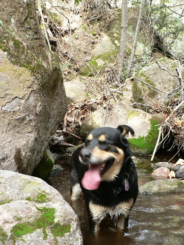
  11. Water report: Two flowing springs at Cienega Camp. You need a cup to capture the water and transfer it to your bottle. No water at Bluff Camp. Also the National Forest sign at Bluff is missing, only remnants of the 4×4 post remains. If you can direct me to uploading pictures, I can send them. The picture you posted of a dog in a stream that is posted after the Bluff camp picture in your blog, was that picture taken at Bluff?

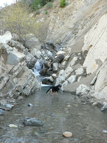
    1. Great update, thanks John! Sad to hear the sign’s gone missing … likely lifted by a “collector.” The image of the heterochromatic hellhound in the creek is that little drainage just above Cienega (that short, steep section of trail as one is returning from Bluff).

      My site doesn’t take photos, but I strongly recommend flickr, google, or a TR on hikelospadres.com to shares your images.

  12. RSO Jonny Avatar
    RSO Jonny

    Headed up to Cienega this weekend with a hearty crew. Will give a full report on trail conditions upon return. To the hills!

    1. RSO Jonny Avatar
      RSO Jonny

      The ‘trail’ up the east fork has improved somewhat, there were slightly less alders whipping me in the face. There was the beginnings of tread up to the narrows. After that it was not as clear. The fire ring at ‘camp solitude’ is still there but no water in the creek at that point.
      The trail up to Cienega was the same, steep. The difference this time were the massive quantities of poison oak. I was nauseous as I gingerly stepped around, over, and under its evil touch. I await this weeks skin developments to see if I had contact.
      The junction with the bluff trail was very indistinct, the 4×4 and forest sign were nowhere to be found. Cienega is just as awesome as always, there was good flowing water in 2 spots, at the bridge and again at a large maple. We did not proceed to Bluff. I give a shout out to those who provided the cast iron cookware at camp, we left it clean and right back where it was found. ‘Uncle Mark’ watched over us, I never knew the man but he seems like a cool dude. Next time I come up I plan on bringing a new bear flag, the current one is in tatters!
      We elected to exit via Santa Paula Peak and Timber canyon rd. This it turns out was not an informed choice. The trail was quite hot, it is a toe-jammer, and the newish property owners were not pleased to see hikers descending. They were polite, I think it helped that I was hiking with Santa Paula locals, but it was very clear that future forays up timber canyon were not welcome. This is unfortunate given the state of the East Fork; honest, thoughtful hikers will have no legal options to reach the peak from the south.
      All in all a good weekend foray into a beautiful, unique corner of forest.

  13. John M. Miller, PhD Avatar
    John M. Miller, PhD

    This was an accurate and well-written description of the approach to the switchbacks leading to the Cienega- and Bluff Camp junction from the old East Fork Santa Paula Creek trail. We bush-whacked the old route in April 1969, beginning where the main Last Chance Trail met the East Fork Trail at the “T”-junction across the creek from Big Cone Camp. Almost all the damage to the route up the East Fork was a result of the two 100-year storms in January and February 1969, respectively. Further, the Class III scramble on that infamous “plaster-of-Paris” slope was a result of a massive landslide of the south-facing canyon slope about 100 m W of the final crossing of the East Fork of Santa Paula Creek where the final switchbacks began in 1969.

  14. Sounds like this trail was as difficult in 2011 as it was in 2020. Maybe it got easier in your mind over the years and last weekend was just a reminder of what the canyon was really like.
    Excuse me, I have to go itch my PO rashes for the next 30 minutes

Leave a Reply

Your email address will not be published. Required fields are marked *